By Dmitri Allicock

Cattle, cowboys and horses, creeks, rivers, wooden bridges, swamps, rain, mosquitoes, jaguars and snakes are the ingredients for a great imaginative western movie. These can also be found in stories on the movement of herds of cattle on the infamous Rupununi Cattle Trail to the coastal marketplace of British Guiana.
On the hoof, cattle were driven along a cattle trail that wended its way from Annai in the Rupununi savannahs through rough terrain to the Yawakuri savannah on the Berbice River, covering a distance of at least 120 miles. At the end of the journey, the cattle were exhausted and wasted. In 1919, the trail was successfully completed and the first head of cattle was driven over it in 1920.
A glance at the map of Guyana reveals that the 5000 square miles of the prime savannah lands of Rupununi is located in the isolated deep south- west of Guyana. In the early ranching period, there was no way to reach the Guyana coast with cattle and no market at all except in Brazil where demand was uncertain and values low. Transportation was a serious problem and waterfalls interfered with river transport. Highways and railways were non-existent, and construction through the forests and swamps was cost prohibitive.
The New York Times Oct. 21, 1917 noted: “A reduction from 4 weeks to one on the time necessary to transport cattle from the interior of British Guiana to the coast will be affected by the construction of a cattle trail from the Annai Savannah on the Rupununi River to the Yawakuri Savannah on the Berbice River, a distance of 120 miles. A loan of $60,000 for the purpose has been authorized by the Combine Court of British Guiana accordingly to a report from the Consul George A Chamberlain, station in Georgetown. Work upon the trail is to begin at once and it should be ready for use early next year.”
The publication further added: “There are at present about 35,000 heads of cattle in the savannah in the Rupununi district, and it is estimated that over 1000 head will be taken over the proposed trail yearly to the Berbice River, and hence transported to the coast for the local market and for export. It was further stated in the court that there was 150,000 head of cattle on the Brazilian ranches near the British Guiana border, and that transportation to the coast would be less expensive by this trail that at present by Manáos and other places where markets were available. This trail will also make access to the interior of the colony for other purposes much easier.”
A1924 British Guiana report stated, “There are very extensive savannahs tracts in the far interior on which at present cattle are being raised. With the provision of the Rupununi Cattle Trail in 1920, it is possible that this region will become the important cattle-raising section of the colony.
Horses are raised in some numbers on the plantations and farms of the coastland. There is, however, the possibility of considerable development in this undertaking when suitable opportunities offer for ready sale. The number of cattle in the country in 1921 was estimated to be 122,886, the number of horses 1,762, sheep 20,602, and pigs 12,312.”
The trail was the brainchild of pioneer, H.P.C. Melville, born1864, former commissioner of the Rupununi district who owned Dadanawa Ranch in the 1880s and felt that the construction of this trail could convey Brazilian cattle and horses to British Guiana’s coast and also as an outlet for the large and rapidly increasing herds of local cattle grazing on the savannah.
The market to the Guyana coast was opened with the development of the cattle trail through the forest just at the end of World War I. The trail was very difficult to traverse, particularly in its early years because of the swamps and long distances without proper feed in the tropical jungles. Losses were extremely heavy and profits small, if there were any. Frequent attacks by jaguars, swimming the Essequibo, parasites and disease took a toll. This trail was somewhat improved in the preceding years and death losses were not as great but weight loss was severe and only the strongest and most rugged cattle could hope to make the trek to the grasslands between Demerara and Berbice River.
One branch of the historical cattle trail ended on the eastern shore of the Demerara River near the mouth of Arakawa Creek- Linden today. A stelling was constructed and herds of “cattle were loaded onto the steamer and punts for transport to Georgetown. The trail supplied fresh beef to the local market of Upper Demerara and supplemented other local livestock.”
Teams of workers and contractors, many from Upper Demerara, had the task of maintaining the trail free of bush, keeping wooden bridges safe and wire fencing along its path. This bush trail became an access into the heart of British Guiana, and traffic went both ways.
During the depression years of the 1930s, cattle scarcely paid the cost of driving them to the market and ranching became a moderately profitable undertaking due to the more favourable markets during and after World War II. After the close of World War II the country was opened to air traffic. With some aid from the colonial government, landing fields were developed and regular traffic by the then Guiana Airways Company was established. Regular shipments of beef from the Rupununi to Georgetown by air began on July 9, 1948.
Despite the high cost of airlifting beef to coastal markets in some quantities, it succeeded due to low production cost. The war years and moment of prosperity for the arduous Rupununi Cattle Trail came to an end with the birth of air transport and in 1953 was permanently closed.
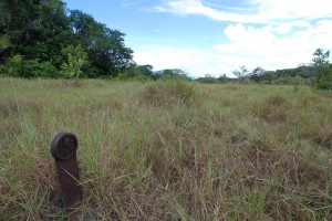
Over the years parts of the cattle trail have been upgraded today into a fair weather track and serves as a road to Brazil, through the town of Linden, ending at Lethem. The jungle has reclaimed other parts of the trail. Iron pegs, which once marked the trail, can still be found buried in the dense growth. Rotting greenheart bridges were still present as late as 1982. Piling remnants of the loading dock alongside the Demerara can still be found today. And so went this one-of-a-kind Rupununi Cattle Trail into the annals of Guyana’s precious history.


