Potaro Bridge

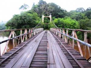
The Montreal Gazette of Nov. 9, 1933 reported under its headline, “Huge Bridge opened. Five Days Cut from Time to Reach Potaro Gold Area” that a new suspension bridge had been constructed over the Garraway River for “the horde of fortune seekers expected to trek across it in search of gold in British Guiana’s hinterland.”
Also known as Garraway Stream Bridge or Denham Bridge, the Potaro Bridge is located at the extreme end of the Bartica-Potaro Road over the Potaro River, some 120 miles from Bartica. Its moniker “Denham Bridge” derives from Sir Edward Denham, at the time Governor Denham of the colony, who declared the bridge opened November 8, 1933.
It is said to be the only suspension bridge in the country capable of supporting heavy vehicles. Spanning 333 feet with two steel trusses suspended by steel cables connected to two reinforced concrete towers on each river bank, the Potaro Bridge was designed to carry a live load of 20 tons.
It was constructed by Scottish civil engineer and general contractor John Aldi (he was interred at Bartica’s Sorrow Hill Cemetery).
According to the Montreal Gazette, the scissors used to cut the ribbon to officially declare the bridge open was made from gold from one of the first shipments that came out of the area.
Demerara Harbour Bridge

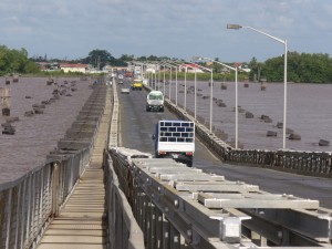
The Demerara Harbour Bridge was commissioned on July 2, 1978, two years after its construction had begun on May 29, 1976.It crosses the Demerara River south of Georgetown, from Peter’s Hall, East Bank Demerara to Schoon Ord, West Bank Demerara.
The 6,074-foot (1,851 m) long floating toll bridge was erected after the government of the day decided there was an urgent need to accomodate the increasing trade and business between the capital city and the west bank of the Demerara River.
The idea of a bridge across the Demerara River is said to have been a dream of the late John Cogland, a sea captain who was also a member of the colonial legislative council. Cogland had proposed the bridging of the two banks of the river as part of a transportation route.
The bridge’s original site was located near Rahaman’s Park. However, the-then harbour master had second thoughts on the site, coming to the belief that it was too close to the wharf at the Demerara Sugar terminal and would become a “navigational nightmare” for ships arriving at the port.
The new site for the bridge between Bagotstown and Peter’s Hall was eventually agreed upon, though its construction plans had to be tweaked a bit since the river was 770 ft wider there than the earlier proposed site.


